New Intelligence added: Airport-surrounding building height restrictions
New Terrain Analysis & Feasibility Reports now live

Three Weeks of Evaluation Analysis Diligence
now in 3 minutes.

Scout. Evaluate. Close. All in one Platform.

Built for faster, smarter land decisions.

Floating island showing land evaluation intelligence layers
AI powered Land Acqusition platform
THE IMPACT OF REALM

Real ground covered, real results.

From land scouting to close — here's what teams move when evaluation runs on REALM.

Acquired on REALM
0Cr+

Worth of land already acquired on REALM — and counting.

Why it adds up
0+
Spatial data layers on every parcel — full picture, instantly.
0%
Faster diligence — three weeks of checks done in minutes.
0x
More deals evaluated every month per team.
The Problem

Wasted site visits

Teams drive to parcels that should've been killed in five minutes with proper data.

With REALM
~0%
Fewer wasted visits — dead plots filtered before anyone travels.
The Problem

No audit trail

The decision gets made, but the reasoning behind it never gets recorded.

With REALM
0%
Of decisions logged with a full, shareable audit trail.
The Problem

Teams work in silos

Site notes, records and broker chats scattered across WhatsApp, Drive, Excel and PDFs.

With REALM
12→1
Tools collapsed into one decision platform.
The Problem

Coverage is patchy

Evaluating across cities and states means stitching data from scattered sources.

With REALM
0+
States actively evaluated on one unified platform.
HOW REALM WORKS

From the first polygon to the final signature.

01
Stage 01Draw

Mark the lead

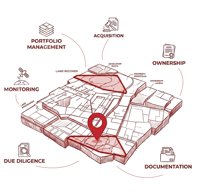
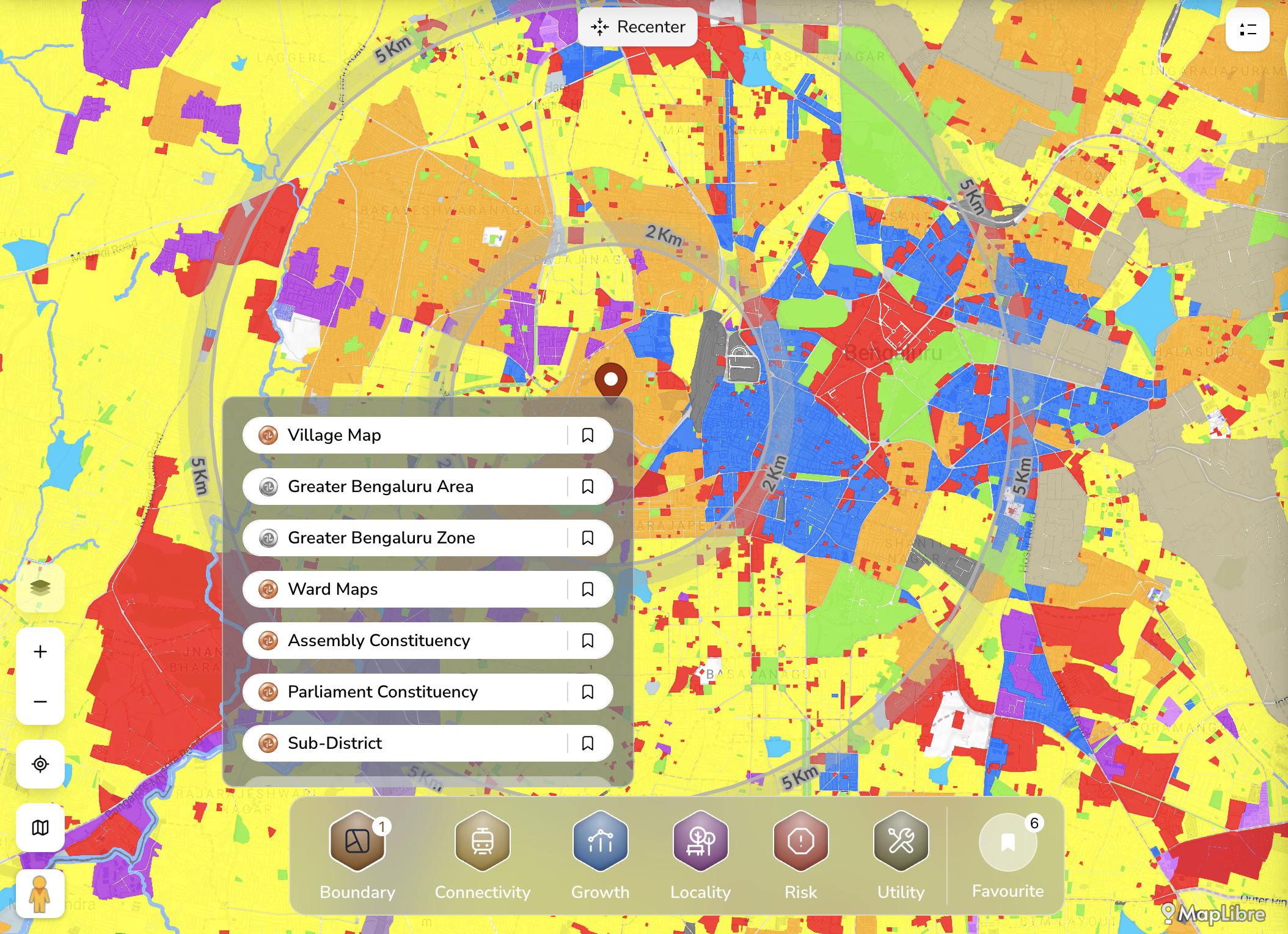
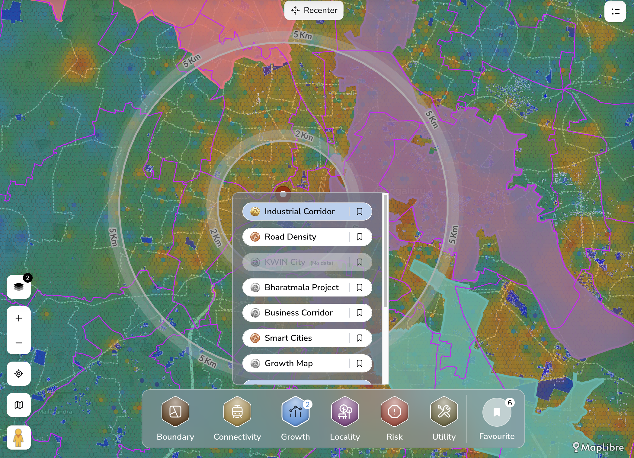
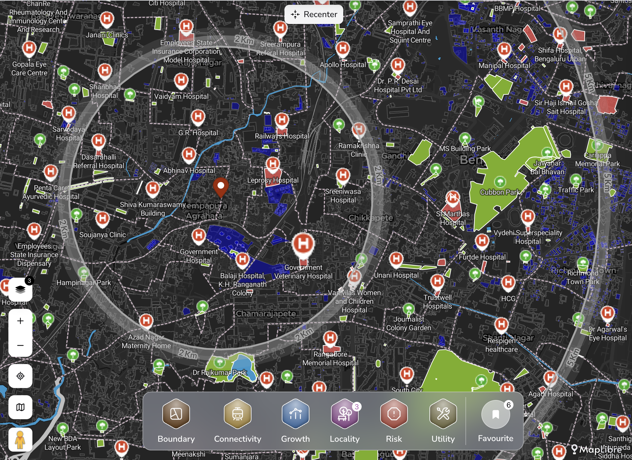
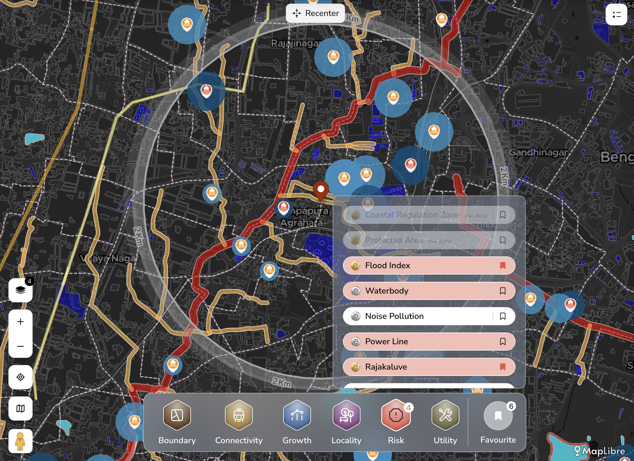
Draw a polygon or drop a survey number — and instantly pull 150+ data layers onto the plot.

Mark the lead — REALM screenshot
01
Stage 01 — Product
02
Stage 02Add

Build the lead

Documents, photos, notes, owner details — all anchored to the parcel, in one place.

Build the lead — REALM screenshot
02
Stage 02 — Product
03
Stage 03Analyze

Evaluate with intelligence

Flood risk, connectivity, growth signals and zoning — assessed across 150+ layers in one go.

Evaluate with intelligence — REALM screenshot
03
Stage 03 — Product
04
Stage 04Track

Move the deal

Track every stage — from sourcing to final call — across your whole team, on one board.

Move the deal — REALM screenshot
04
Stage 04 — Product
05
Stage 05Close

Lock the deal

Every decision logged with the data behind it. Every stakeholder aligned. Every deal defensible.

Lock the deal — REALM screenshot
05
Stage 05 — Product
Five stages. One platform. Zero blind spots. Book a Demo
WHAT YOU CAN DO WITH REALM

India's most complete land acquisition platform.

Scout, evaluate and close — every tool your land team needs, on one platform.

Land lead management

  • Track every land parcel through your acquisition pipeline — from first lead to final call
  • Assign leads to team members
  • Status updates and activity log
  • Filter by stage, location, or priority

Map tools

  • Draw a polygon to mark land boundary
  • Auto area calculation
  • Find Elevation

Spatial insights

  • 150+ data layers on every parcel
  • Growth, connectivity, risk, boundary
  • Guideline value & survey data
  • Competitor analysis

Smart dashboard

  • Every lead stage and metric in one live view
  • Pipeline overview at a glance
  • Lead stage tracking
  • Team activity & updates
AI Powered

AI reports

  • Auto-generated land reports
  • Location analysis & risk signals
  • Shareable with stakeholders
  • Feasibility report

Documents, media & notes

  • Every file, photo & voice note linked to the lead
  • Document & photo storage per lead
  • Voice note recording on the go
  • Full audit trail per parcel
Swipe to explore
DATA INTELLIGENCE

Every data your team needs on every parcel — structured & ready to act on.

Boundary layer preview Connectivity layer preview Growth layer preview Locality layer preview Risk layer preview Utility layer preview
Boundary
01 / 06

Where exactly does your land begin and end

    Explore in REALM
    WHO USES REALM

    Who uses REALM?

    A systematic approach to land acquisition with AI & data.

    Real Estate Developers

    Residential, commercial, mixed-use. Run your entire acquisition pipeline on one platform.

    Hospitality

    Hotel chains, resorts, serviced apartments — pick the right site before someone else does.

    Industrial & Logistics

    Warehousing, manufacturing, data centers. Large-format parcels with verified industrial zoning, connectivity scores and buildability.

    Investors: PE Funds & Family Offices

    Evaluate acquisition targets, monitor portfolios, and flag risks across hundreds of parcels from one dashboard.

    Infrastructure & Energy

    Highways, metros, renewables. Map ownership patterns across corridors, plan acquisitions at scale, track every parcel from notice to signature.

    Retail & F&B Chains

    Scouting 10 stores or 1,000. Catchment data, zoning verification, comparable rents — the right site, chosen in minutes.

    PRICING

    Built for growth at every stage

    Simple, transparent plans that scale with your land team.

    Monthly Annually Save 20%
    Starter
    ₹60,000 30,000 /quarter
    What's included:
    • Up to 25 properties
    • 1 team member
    • Workflow & tracking
    • Documents, media & notes
    • Survey maps
    • Area & elevation
    • 50,000 coins / quarter
    • Intelligence layers & AI reports
    Get Started
    Enterprise
    Custom Pricing
    What's included:
    • Unlimited properties
    • All features, exclusive access
    • Dedicated account manager
    • Unlimited intelligence access
    • More users
    • More storage
    Contact Sales
    Trusted By

    The industry's biggest leaders trust TalkingLands.

    From national developers to infrastructure majors — teams acquiring land across India run it on TalkingLands.

    Client 1Prestige
    Client 2Hosachiguru
    Client 3KVN Groups
    Client 4Godrej
    ₹3,000 Cr+Land evaluated
    20+States covered
    150+Data layers
    25M+Datasets
    99%Faster diligence
    Privacy & Security

    Your data stays locked.

    Every parcel, document, and decision in REALM is encrypted in transit and at rest. Your portfolio is yours alone — never shared, never sold, never seen outside your team.

    • Encrypted end-to-end

      In transit and at rest — industry-standard, audited.

    • Locked to your team

      Workspace-isolated, role-based access. You decide who sees what.

    • Never shared, never sold

      Zero data resale, no third-party access, no ad integrations.

    Sriram Chitlur, Co-founder of TalkingLands
    Founder's Note
    The real bottleneck has never been construction — it's what comes before it: making sense of fragmented, opaque land data. We're turning that blind spot into a transparent, data-driven workflow — bringing revenue records, survey data, Master Plans and infrastructure onto a single map, so teams evaluate parcels in hours, not weeks.
    Sriram Chitlur
    Co-founder, TalkingLands
    FAQ

    Common questions.

    1 What is REALM by TalkingLands?

    REALM is a B2B land acquisition platform built for the Indian market. It combines 150+ verified spatial data layers, deal-pipeline management, and AI-powered property reports in a single map-first interface. Teams use it to evaluate land, track deals from sourcing to final call, and make faster, data-backed acquisition decisions.

    2 Who uses REALM?

    Real estate developers, industrial and logistics companies, infrastructure firms, hospitality groups, retail chains, PE funds, and family offices — any organisation that acquires land in India.

    3 How does REALM speed up land due diligence?

    Traditional land due diligence in India takes 3–6 weeks — verifying zoning, FSI, master-plan overlays, buffers, and connectivity across multiple government offices. REALM pre-loads 150+ verified data layers on every land parcel the moment it's added. Teams can assess flood risk, zoning, infrastructure proximity, and growth signals in minutes instead of weeks, and get a complete report of the land and its feasibility in minutes.

    4 Is my data secure on REALM?

    Every organisation gets a private, isolated environment. Your portfolio, properties, and pipeline are visible only to your team. No cross-client data sharing. Enterprise-grade encryption with role-based access control and a full audit trail on every decision.

    5 What are the common risks in Indian land acquisition?

    Zoning mismatches, SWD and road-buffer violations, master-plan conflicts, setback non-compliance, encroachment, and infrastructure changes. Property disputes make up 66% of India's civil court backlog, with 5+ million cases pending (NJDG, 2026). Most start with missed diligence at acquisition.

    6 How long does land due diligence typically take in India?

    Standard land due diligence takes 3–6 weeks and involves verifying FSI, zoning, master-plan overlays, environmental buffers, and title across multiple government departments. For complex titles or disputed land, timelines stretch to 6–12 months.

    Looking to streamline land acquisition with data?

    Book a 30-minute demo.

    Book Demo
    TalkingLands Technologies Pvt Ltd, No.125, G K Arcade , Ashoka Pillar main road, Jayanagar East, Bengaluru, Bengaluru Urban, Karnataka, 560011
    Get the latest news and updates

    Subscribe TO RECEIVE LATEST UPDATES

    Thank you! Your submission has been received!
    Oops! Something went wrong while submitting the form.
    © 2023 TalkingLands Pvt Ltd. All rights reserved.